ArcCI Architecture Diagram
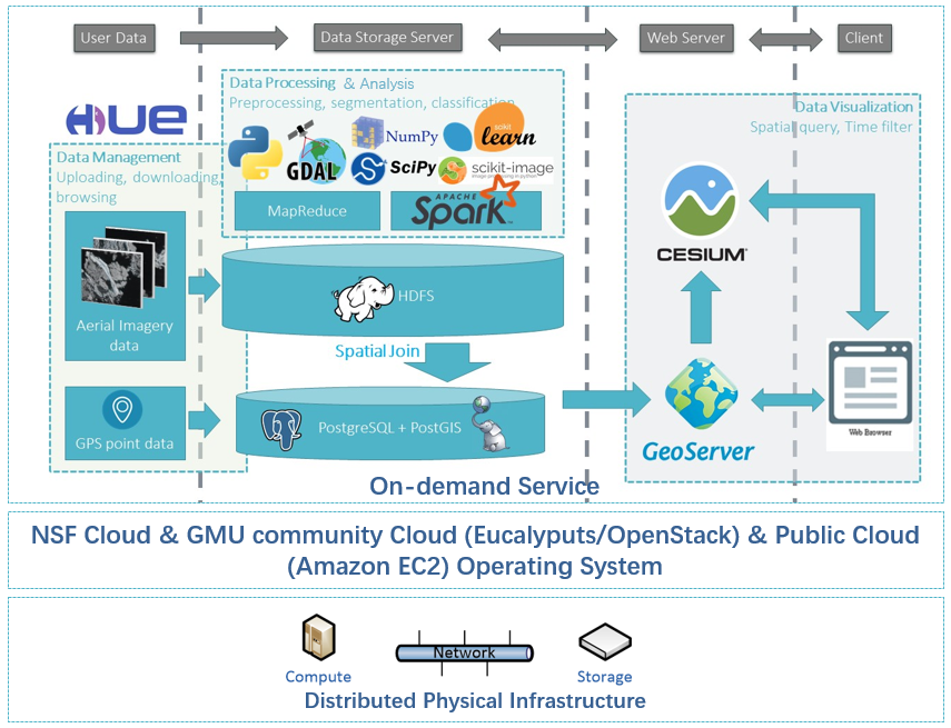
ArcCI is designed and developed to support on demand arctic HSR image processing. We detail each part of the architecture for ArcCI from bottom to top.
The distributed physical infrastructure layer (bottom layer) provides the physical computing resources for supporting all computing requirements of the system. Above the physical infrastructure layer is a software layer that includes the operating system, cloud software, and database management system, providing cloud advantageous services such as elasticity and on demand. Virtualized machines are utilized to ease the system development, integration, and deployment.
Software layer includes the community private cloud computing environment at Gorge Mason University (GMU), and the public cloud computing environment at Amazon, both of which are serving the public through the NSF spatiotemporal innovation center, with integration to best leverage the cloud computing environment for sea ice research.
The top layer is developed to provide different types of on-demand services including Extract-Transform-Load (ETL) process and data storage, image processing, parameter extraction, and spatiotemporal visual analyses. This layer also provides a graphical user interface (GUI) for geo-search and query functions, and it can be remotely used by desktop computers or mobile computing devices, so as to support the data life cycle of generation/discovery, processing, analyses, and visualization for end users. On the top of the three-layer architecture, many applications can be customized by end users based on specific polar science research requirements.
Reference:
Sha, D., Miao, X., Xu, M., Yang, C., Xie, H., Mestas-Nuñez, A. M., … & Yang, J. (2020). An on-demand service for managing and analyzing arctic sea ice high spatial resolution imagery. Data, 5(2), 39.
Tian, L., Xie, H., Ackley, S. F., & Mestas-Nuñez, A. M. (2020). Assessing Scale Dependence on Local Sea Level Retrievals from Laser Altimetry Data over Sea Ice. Remote Sensing, 12(22), 3732.
Dai, L., Xie, H., Ackley, S. F., & Mestas-Nuñez, A. M. (2020). Ice Production in Ross Ice Shelf Polynyas during 2017–2018 from Sentinel–1 SAR Images. Remote Sensing, 12(9), 1484.